A Place of Grandiosity

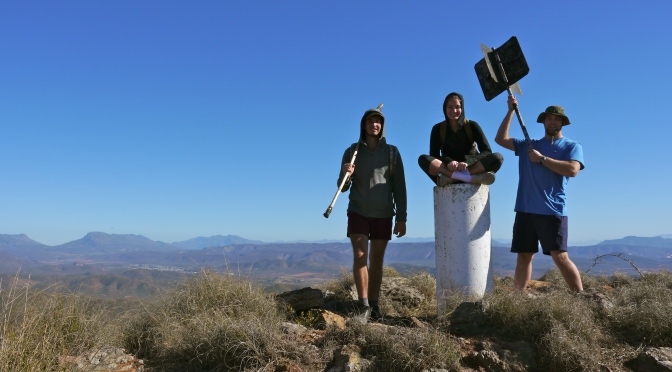
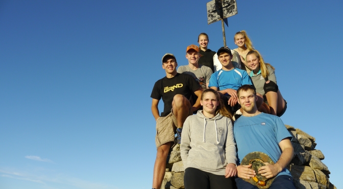
In the winter holiday of 2019 a group of students decided to answer the mountains’ calling and set out into the Riviersonderend mountain range. We decided to pack our bags and overnight on the crest of the mountain.

The five of us set out in a foggy, overcast sky. This made the fynbos with water beads hanging from the leaves  take on a crisp green color. As we walked into a dense cloud, the whole scene chanced as we were surrounded by whiteness, large sandstone boulders with various shapes appearing as if from nowhere and the song of seemingly near sunbirds filled the surround.


The trail was an old jeep track, so we only faced the increasing incline as we neared the crest. We only carried our drinking water for the two days as I was banking on the fact that we ought to come across several mountain streams as it was raining a lot the past few days. I was surprised and eventually a bit anxious as we reached dry stream upon dry stream. We would have no water for preparing our food or drinking coffee on top.

This was likely because it was still early winter and the ground was not yet saturated enough  for the land to form water streams.

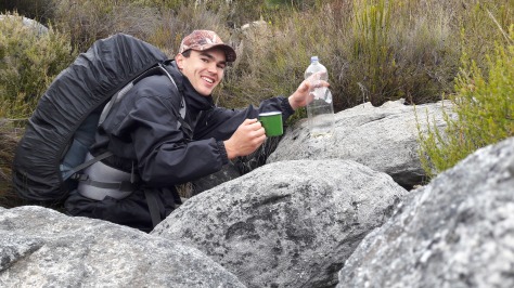
Someone was looking after us as, much to my relief, we eventually found a small, steady mountain stream just before our final steep ascent. We could fill up and not have to ration on our water. No dry 2-minute noodles and oats for us!

20190625_141614
We’ve found water!

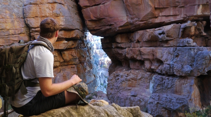
Our final ascent took us even higher unto the mountain and we became completely enveloped in the clouds. With the view hidden from us, we pushed on and made our camp for the night.

To our surprise and delight, it was almost completely wind still on the mountain crest. We prepared our supper while sitting in our tents – a mix of bacon, green pepper, onion and 2-min noodles finished off with a cappuccino and chocolate!


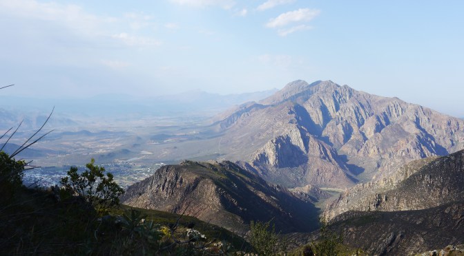
Morning greeted us with one of the most spectacular sunrises we’ve ever seen! The valley was partially covered in a blanket of mist with the mountain ranges surrounding us protruding like large spiky islands. Some clouds still on our altitude came rushing towards us which created a very dramatic scene with the sun rising in the distance.

We ate our oats and coffee breakfast in style while sitting and taking in the scenery around us. Eventually we packed up and forced ourselves down the mountain back to the busy modern life of humans.


I’ve been on this mountain a couple of times and I have always left with an impression of the humbling grandiosity of our natural world.

Epic Mountain Experience

This nature reserve is located along the slopes of the Langeberg mountain range near the town of Heidelberg in the Western Cape, South Africa. See CapeNature for more info. See coordinates.

After a full year of medical school, a friend and I decided it was about time for an epic adventure! This was our December summer holiday of 2018.

Booking was necessary and hassle-free. The price for the basic shelters at Helderfontein was R60 per person with and additional R40 conservation fee per person per day.

Day one was started with great enthusiasm despite knowing that we were going to face some rainy weather. The trail led us through patches of burnt fynbos creating an unique contrast between the charred earth and the green sprouts of grass, ferns and restios arising from the ashes.

The unique Fire Lilies stood out scarlet red from the black earth – what a sight they were! These are lilies known to only bloom about two weeks after a summer wildfire. 

Other fynbos plants we could recognize among the vast diversity were the King Protea and Pink Disa. 

The higher we climbed, the worse the weather got in terms of wind and rain but not of enjoyment! Because we couldn’t see the surrounding landscape, we it was hard to guess our location on the map accurately – we just kept following the trail into the never-ending white abyss. With great relief and 16km later, we saw the two shelters revealing themselves through the white.

The huts, called Helderstroom Huts, were basic (as we were informed) but all we needed – four walls, a roof and a dry floor. We picked the one with the least amount of animal nests and odor. We prepared ham and mushroom pasta on our stove with coffee. While enjoying our food, a mouse revealed itself  from the floorboards – causing a brief surge on unnecessary adrenaline! Except for a bat making a brief visit to our shelter, the long, cold night on the hard floor went by uneventful.

The next day welcomed us with a soft drizzle of rain and a chilly breeze entering through the open door and window. We forced our stiff muscles and aching joints into motion so we could pack up and set out. The hardest thing to do was to put our warm, dry feet into the cold, wet boots!

We decided to return via the same 16km on which we came as the Duiwenhoks River on day 2’s trail is liable to flooding and hikers are advised to avoid the crossing during rainy weather. So with aching bodies, saturated boots and a long road ahead, we set out in a comfortable silence.

The road back, being familiar trail and downhill but not shorter or less rainy, passed by  quicker that we thought. Before we knew we were among the patches of burnt fynbos with the Fire Lilies again.

The Boosmansbos Wilderness 2 Day Trail was an epic experience of nature’s extreme conditions and pristine beauty! A trail well worth hiking, whatever the weather. 

Towards an Italian Cross in South Africa!

Weekends when I drive home, I have to cross the mountains via the Du Toitskloof Pass. I  notice this trail’s starting point every time I drive past. Eventually an opportunity came and a friend and I made good use of it!

Some interesting history: The pass is named after Francois Du Toit who with the Huguenots (an ethnoreligious group of French Protestants ) arrived as refugees in the Cape colony, fleeing religious persecution in their own country. He and his family were the first people to farm on the mountain slopes nearest to the where the pass is today. The mountain pass was built in World War II by Italian prisoners-of-war for whom the cross was erected on Huguenot Peak. (Read more about its long and interesting history)

Setting out early isn’t always as easy in summer time. It was a struggle to get out of bed and prepare for the hike. Eventually we reached the start at 10 am, the day was already getting warm and everything nearly basked in the sun.

DCIM100GOPRO

The trail led us up the Miaspoort ravine where we scrambled over a rock slide and between some shrubs before we started to climb the Small Drakenstein mountains. The climb was slow and steady, taking breaks often to look back at the Cape Winelands which was quickly getting smaller and smaller.

On top of the mountains, the trail took us on a plateau where we had breathtaking views of the surrounding mountain ranges.

On top of Huguenot Peak, it was already noon and the sun was beating down on us. We sat in the shade of a large boulder, absorbing the silence and vastness around us. The cross was erected in memory of the Italian prisoners-of-war who build the Du Toitskloof Pass in World War II.

While we sat there two falcons were circling us. How free they must be, we wondered, only concerned with the tasks of basic survival. Well rested, re-hydrated and re-lathered with sunscreen, we headed back.

Walking down the mountain, we took in the last bits of scenery and freedom before returning to our student existence on Monday.

A Coastal Snack

Some holidays we camp along the West Coast of South Africa. The area is an arid region with consequently evolved fauna and flora. Examples of these adaptations are the fleshy leafs of “vygies” and flowers that emerge and bloom only with the annual rains creating spectacular spring landscapes. You have to click here. Its an interesting landscape where the coast, buzzing with life, is merged with the arid Namaqualand which has much less ecosystem diversity and density.


Some Namaqualand photos:

Some coastal pictures:

Scattered along the South African coast are ample sites showing evidence of paleolithic (palaios = ancient and lithos = stone) life like stone tool workshops or rock art. I sometimes wonder how these people lived. Modern day technology can be so distracting and overwhelming that I often find myself longing for the primitive and more connected existence of our ancestors.

One early morning with most of the camp’s inhabitants still asleep, my grandpa and I made out escape for the coast. Our goal: to take only the bare minimum and try and relive what might have been a coastal snack for the ancient people that dwelled this land.

Mussels are bivalve mollusks (thus having laterally compressed bodies enclosed by a shell consisting of two hinged parts). It feeds by filtering water through its gills. In adult form they are permanently attached to rock via its byssus.

Male and female mussels reproduce by releasing eggs or sperm. These join and become free-swimming larvae which spreads through the water, attaches to fish’s gills and fall off once they are mature enough. The survivors eventually find a suitable location to attach to. Check out this article for more information.

Mussels come forth in densely packed colonies on the intertidal rocks. Their prey along the west coast include the beautiful girdled dogwhelk (see how it feeds on the mussels) and the African Black Oystercracker.

One prepares mussels by steaming them until the shells open. The male mussels appear pale white while females have an orange appearance. Mussels are rich in protein, Omega 3, good fats and the essential vitamins and minerals. Considering this and their abundance, mussels must have been a type of super-food for the ancient people that lived along the coast.

I enjoyed experiencing the whole process of selecting, cooking and eating. It gives one a better relationship with the food one eats as Mark Healey says in the series “Connect not Conquer”.

Wolfberg Cracks

During some long weekend my grandfather and I went on a trip to the Cederberg region. Of all our experiences there, the one we had on Wolfberg was the most memorable.

What made it so memorable was the rock formations. The rock type that gave rise to this spectacular formations is called the Upper Peninsula Formation sandstone. A reddish, soft and easily eroded rock giving rise to the many rock shapes and caverns. Good examples are the Wolfberg Arch and Cracks which we visited.

We slept at Sanddrif Holiday Resort so that we could be as close to the start of the trail as possible. In the early morning gloom of what seemed to become a hot day, we set out on the trail.

The main attractions of the trail are on top of  Wolfberg mountain which means you have to climb an odd 633m accent. We startet out early and upon reaching the top, the great rock faces were just starting to warm in the golden light of the rising sun. Somewhere between these shear cliffs is where you enter the cracks.

In the cracks , with the rays of the sun far from reach, the two of us made our way through the labyrinth with child-like excitement. The experience of walking about 30m below the surface was nothing but otherworldly.

After traversing the cracks, we emerged from the depths and the warm summer sun greeted us back. From there you can either hike another 5km to the Wolfberg Arch (an iconic Cederberg landmark) or return down the mountain via a big, easy crack. We went to the arch and returned thereafter.

The trail to the cracks and arch isn’t easy. It’s a total 7+ hours but a  fun packed 7+ hours. Definitely something for the bucket list!

A hike in the arid Robertson Karoo

Beyond the Boland and Riviersonderend mountains of the Cape, the rainfall becomes much less which results in the dominance of more hardened, water conservative ecosystems. Many species of succulents  together with numerous dwarf trees and shrubs make this region their home. On higher slopes and ridges one can find patches of renosterveld and along the (mostly seasonal) riverbanks, groves of sweet thorn trees grow.

The succulent karoo is a spectacular ecosystem because it gives one an appreciation of nature’s ability to adapt to harsh climates and still flourish.  The land here is home to various elusive creatures who mainly come out between dusk and dawn like the duiker, cape mountain leopard, porcupine, pangolin and grey rhebok. I’ve heard a interesting theory from a farmer once – he said the reason why mammals like the rhebok, duiker and leopard weren’t hunted to extinction when the Europeans came was because they are elusive and nocturnal animals. This is probable because one never sees any signs of life during the daytime unless you stumble upon a duiker resting in the shade or such.

Vrolijkheid Nature Reserve is situated between the towns of Robertson and McGregor in the Breede River Valley. It hosts various facilities and trails – worth the visit! The Rooikat Trail is a 19km route taking you up the Elandsberg mountains offering spectacular views of the surrounding landscape. There’s no water along the way, the route is strenuous, takes about 8 hours to complete and you’re in the sun the entire time = come early and prepared!

What makes this trail unique is its remoteness and length. Nowhere in the popular routes will you have the privilege to spend a day out on the trail by yourself (plus your companions) in the company of only the stillness of the views and the beauty of mother nature. At the end of the day everyone’s feet are aching and tired but there is a mutual feeling of gratitude to be able to live on and experience such a wonderful Earth.

Bloupunt Hiking Trail

On Route 62 (South Africa) lies the town of Montagu. It lies in a type of basin surrounded by mountains with the most intricate geological shapes and formations making it a heaven for rock climbers and anyone with the adventurous streak. It is actually one of the world’s top rock climbing destinations. Montagu is also known for its muskadel, dried fruits and rich cultural history.

On a warm, humid winter morning before the next cold front, Andreas and I set out on the Bloupunt 16km trail.

As if for the first time, we were blown away by the pure undistilled beauty of the Earth. We started off in a grove of eucalyptus trees and entered the ravine (Donkerkloof) were we saw large blooms of arum lilies and patches of small cobra lilies.

We were talking lazily until the ascent started which took us out of Donkerkloof, 400m up onto the Langeberg mountain range. There we were surrounded by the famous Cape fynbos. We saw a variety of protea: waboomlaurel and sugarbush protea. These attracted many sunbirds which accompanied our trek through the fynbos.

While traversing the Southern slope, we had amazing panoramic views of the vineyard country below. Upon summiting, we had a lunch break while taking in the views. We also inspected the sundial and found the visitors book missing unfortunately.

The descent back into Donkerkloof was quite steep and tough on the knees. This hardship was contrasted by the intricate rock patterns of the opposing cliff face. While staring at these folds in the mountain, millions of years in the making, I noticed a large shadow skidding across the rock face which turned out to be a black eagle gliding close by.

Before long we were plunged back into the damp, dark and muddy arena of the ravine. Back on level ground and with the knowledge that there was no more mountains to climb, we had a new spring in our step and avidly started exploring the three waterfalls along the ravine. I was surprised that the river was still going strong despite one of the biggest droughts South Africa had faced in years. In one of the waterfalls there was a cave with a colony of bats.

The last few kilometers of the day were spent in bittersweet moments of gratitude for not having to hike another 15,6 km and the privilege we had to have had such an amazing experience of nature!

Up Arangiekop again!

With my first year of university behind me, it’s time to return to Arangieskop. What a spectacular hike it was!  

Arangieskop is a peak of the Langeberg mountain range (literally meaning long mountains) near the town of Robertson, Western Cape. The ascent is steep but takes you through pristine mountain fynbos and through a ravine where you can stop for snacks and take a swim! You overnight on the very snug hut on top of the mountain. Day two you summit and take the long and steep decent down to the Robertson wine valley below.

The morning of the final ascent, we saw the most beautiful sunrise above a blanket of clouds covering the valleys below.

Enjoy the video and if you ever get the chance, endeavor to ascent this peak!

This slideshow requires JavaScript.

For more info click on the link: http://www.campingandhiking.co.za/jl2/index.php/hikes/weekend-hikes-menu/arangieskop-robertson-march-10-menu

Hanklip’s Secret

Ever been in the area of Betty’s Bay, Pringle Bay or Rooiels? Then you must have hiked up or least know of Hangklip. Well not many people know of its secret deep within the mountain – a cave! Also the home of some bats and a ancient tree. 

What type of cave?

A talus or scree cave. This type of cave is formed by openings between large boulders fallen into a random heap. The Hangklip cave is the result of it being in an gulley which resulted in water removing all the soil between these boulders resulting in an talus cave.

The “entrance” to the cave is situated under a giant white milkwood tree (a tree unique to southern Africa) which’s fruit are conveniently part of the resident bats’ diet. This particular tree my family like to call the “fairy tree” because it feels enchanted especially when making the transition between  the sunny fynbos outside and the damp, shaded interior of the milkwood tree.

This slideshow requires JavaScript.

Look for the path leading to the cave (34°21’57.8″S 18°50’00.7″E) and cherish this small piece of paradise.

Stony Point Penguin Colony, Betty’s Bay, South Africa

An African penguin population at Betty’s Bay provides opportunities for the public to observe them in their natural habitat.  The African penguin is experiencing a catastrophic decline in its global population.   As a result it is classified as endangered by the IUCN Red List.  Stony Point is the only mainland colony of African Penguins that is known to be expanding.

The penguin colony at Stony Point started in 1982 and has subsequently grown to about 150 pairs.  African penguins breed with one partner for their entire life. Each breeding pair will return to the same breeding colony and same nesting site each year.   The age at first reproduction ranges between four and six years and life expectancy is up to 27 years in the wild.

African penguins are flightless aquatic birds with reduced wings that are modified to form efficient flippers for swimming.  They have heavy bones to enable them to dive.  The feathers in adults are specialized to form a thick coat of overlapping layers that assists with waterproofing, wind resistance and insulation.  The penguin has a black bill and shortened tail. Each African penguin has a unique and distinct pattern of black spots on the white chest that can be used to distinguish individuals from one another.

The distinct pink patch of skin found above the bird’s eye helps the bird to cope with changing temperature.  As the external temperature around the African penguin increases, the bird’s body sends more blood to the glands found at these pink patches of skin, causing the pink patches to change color and turn a darker shade of pink. This in turn causes the glands to be cooled down by the air surrounding it.

The African penguin’s black and white belly coloration is an important form of camouflage at sea. The white belly deters predation from underwater predators looking upwards and the black deters detection from predators swimming above the bird whilst looking down onto the dark depths of the water.

African penguins is a charismatic species that is known for its loud donkey-like braying noises (hence the nickname Jackass Penguin), distinctive black and white plumage and large breeding colonies. They are very clumsy on land, waddling upright with flippers held away from the body as if they are drunk.

Written by Van As Jordaan, uploaded by Jacques Jordaan.

Nature, Outdoors, Wildlife and Hiking in South Africa

Through Open Lens

Home of Lukas Kondraciuk Photography

Circadianreflections Blog

“A good snapshot keeps a moment from running away.” ― Eudora Welty

Pearl St. Gallery

Capturing Images of Life

Iowa Girl on the Go

An Iowa travel and discoveries blog